


Monitoring of Oceanographic and Meteorological Information in the Harbor Area via the Harbor Environment Information Website
- Date:2023-08-08
- Update:2024-01-31
- Department:Transportation Technology Research Center
Oceanographic and meteorological conditions are relative to ship navigation, harbor’s passenger and cargo operations, and water recreation in the port area. The Institute of Transportation, MOTC, has established oceanographic and meteorological observatories in each commercial port. The Harbor Environment Information Website has been created to provide real-time observations of oceanographic and meteorological conditions (wind, wave, tide, current) as well as 48-hour forecasts in nine commercial ports. The information is searchable and applicable by harbor structure planning, design, and maintenance units, port area construction and operations, ferry passengers, and fishermen. It also serves as a reference for navigation by carriers, support for port authorities' management and decision-making, harbor structure design, etc., all of which will enhance port area operations and the safety of users.
The oceanographic and meteorological data includes wind force (wind velocity and wind direction), wave (wave height, wave period, and wave direction), tide level, and current (flow velocity and flow direction). Keelung Port, Taipei Port, Suao Port, Hualien Port, Taichung Port, Budai Port, Anping Port, Kaohsiung Port, and Fuao Port in Matsu are the nine commercial ports.
The Harbor Environment Information Network (HEIN) provides real-time and predictive oceanographic and meteorological information, and information regarding the likelihood of typhoons impacting the port area, information of seismic intensity and surface acceleration in the port area caused by earthquakes, information of metal erosion rates in the port area, monthly statistical data of oceanographic and meteorological observations, and the maximum tsunami-caused wave height in the port area. In addition to webpages, harbor environment information maps have been created to display oceanographic and meteorological data through the use of an overlay and particle effects. Both the webpages and maps have a responsive design, allowing users to view them on desktop computers, tablet computers, and mobile devices.
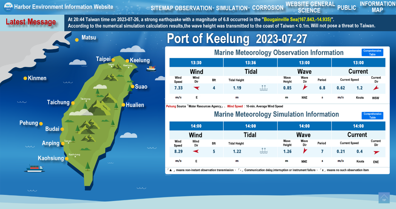
Figure 1 Web page screenshot of the Harbor Environment Information Network
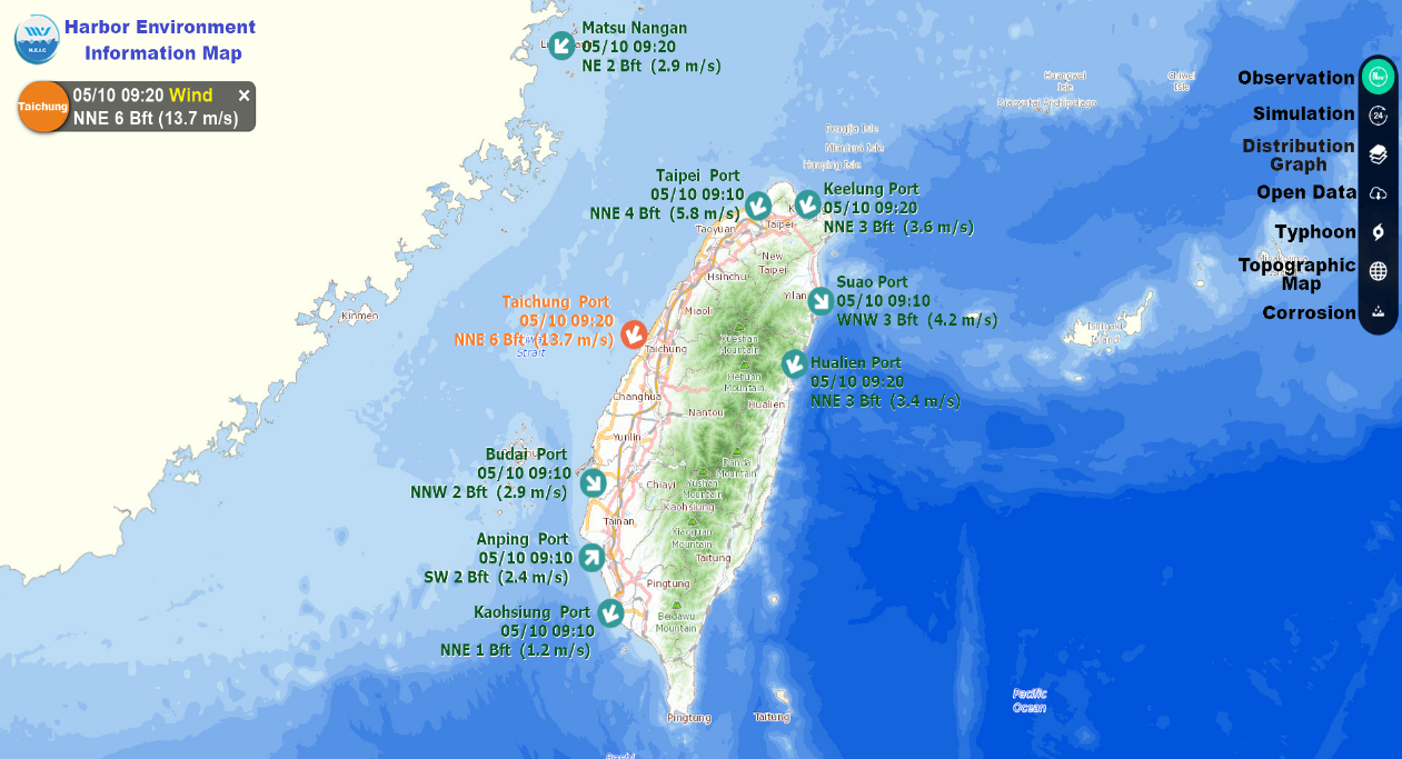
Figure 2 An image of a harbor environment information map
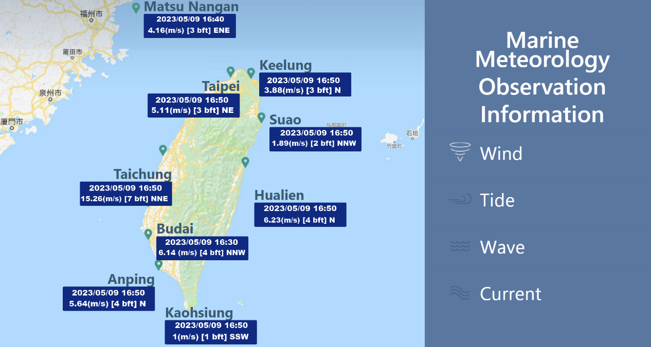
Figure 3 Oceanographic and meteorological observation data for nine commercial ports
File Download
- 1120808-news.pdfCounter:110