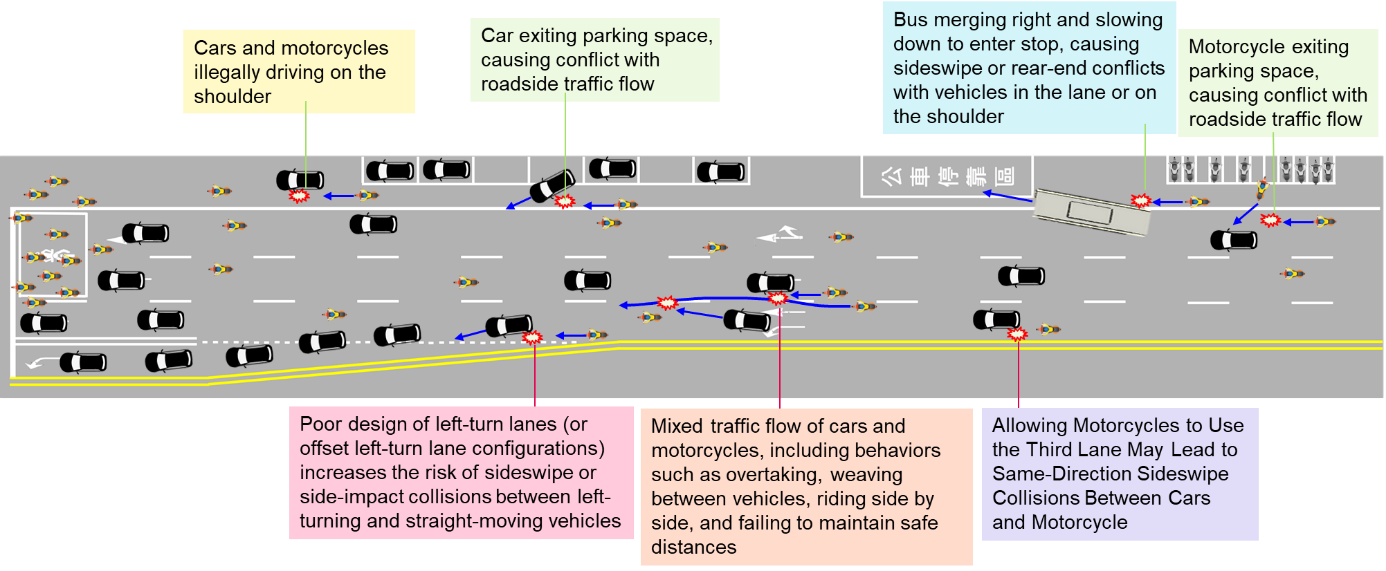
From 2021 to 2023, the IOT conducted traffic conflict analysis at intersections, integrating drone aerial imagery with traffic applications. This initiative led to the development of a software platform for traffic conflict analysis, which has been used to assess 12 high-risk locations across 9 counties and cities. The platform visualizes traffic conflicts at intersections and provides vehicle flow analysis, equipping road management authorities with precise data to make informed improvement decisions. To gain a comprehensive understanding of the interaction between people and vehicles on roads and the causes of overall traffic conflicts, this project expands the analysis scope from intersections to road segments. As illustrated in Figure 1, potential traffic risk scenarios on road segments include motorcycle-vehicle mixed traffic conflicts, conflicts between left-turning and straight-moving vehicles, as well as roadside conflicts such as vehicles parking along the curb or pulling out into traffic.
Since road segments cover a larger area, drones need to operate at higher altitudes compared to intersections. By flying at an altitude of 100 to 200 meters, drones can capture a clear top-down view of pedestrian and vehicle movements along the road segment. Then AI-powered image recognition technology is used to convert the videos into trajectory data for pedestrians and vehicles. Finally, software analyzes these trajectories to identify locations and patterns of frequent traffic conflicts—areas with a high risk of accidents. This process can help road management authorities diagnose potential hazard hotspots along road segments.
When improving intersection traffic safety, road management authorities typically need to collect and analyze 1 to 3 years of traffic accident data to identify safety issues before implementing improvements. This reactive approach aims to prevent further accidents. However, to proactively mitigate risks and prevent potential accidents from escalating into serious injuries or fatalities, the IOT has developed a series of projects that significantly reduce data collection time to just 5 months. By utilizing image analysis and quantitative data, we can diagnose traffic conflicts and propose targeted safety improvements, enhancing both planning quality and operational efficiency.
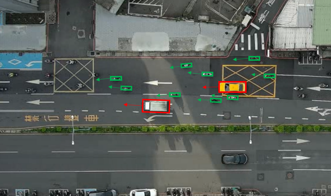
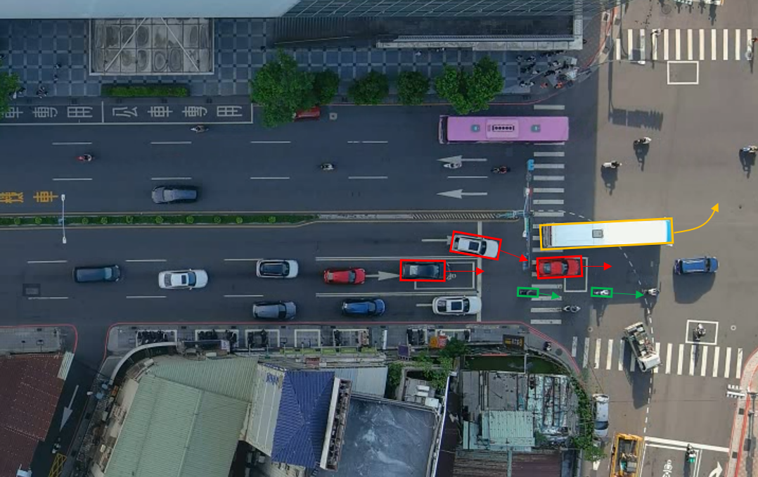
In 2024, the project focused on lane traffic conflicts along road segments. In addition to developing a more comprehensive traffic conflict analysis tool, we collaborated with Taipei City and New Taipei City on two pilot studies: “motorcycle-vehicle mixed traffic conflicts” (Figure 2), and “left-turn lane configuration and traffic flow patterns” (Figure 3). These studies covered a total of 9 road segments. Additionally, the project analyzed two accident-prone locations under the jurisdiction of New Taipei City and Highway Bureau, MOTC.
In 2025, the second year of the project will continue working with road management authorities to study roadside traffic conflicts, including: “conflicts involving buses entering and exiting bus stops,” and “conflicts caused by vehicles to and from roadside facilities.” This analysis will help assess road segment safety. Simultaneously, two additional accident-prone locations will be selected to support road management authorities in applying traffic conflict analysis data and referencing traffic engineering design examples to implement improvements by traffic engineering. Through the technologies and analysis methods developed in this project, road management authorities will have access to more objective and efficient tools for diagnosing road safety issues and formulating effective countermeasures to enhance pedestrian and vehicle safety.

Figure 1: Potential Traffic Risk scenarios on road segment

Note: Identifying Cars (Reds) and Motorcycles (Green) in Mixed Traffic Across Lanes
Figure 2: Insufficient Lane Markings and Poor Lane Configuration Leading to “Motorcycle-Vehicle Mixed Traffic Conflicts”

Note: Identifying Cars (Red) and Motorcycles (Green) in Upstream Traffic of the Left-Turn Lane
Figure 3: Poor “Left-Turn Lane Configuration” Causing Left-Turn Waiting Vehicles to Disrupt Straight-Moving Traffic


