


The Taiwan Highway Capacity Manual is an important reference for transportation planning, roadway design, and traffic impact assessment in Taiwan, helping ensure consistency in evaluating transportation infrastructure projects nationwide. Highway merging and diverging areas (Figure 2), where vehicles frequently change lanes, are among the sections of highways most susceptible to traffic congestion and operational bottlenecks. In recent years, with the rapid development of drone and AI-based image recognition technologies, IOT has applied these emerging technologies to collect traffic data and establish analytical models that better reflect the characteristics of highway traffic in Taiwan, providing the basis for this revision of the Highway Capacity Manual.
The research incorporated drone aerial surveys and AI-based computer vision technology (Figure 3), effectively addressing limitations of conventional traffic surveys, which often require installing numerous cameras and other equipment, substantial manpower, and manual data interpretation. Drones enable comprehensive observation of highway traffic operations while significantly reducing on-site operational risks and equipment costs. Combined with AI-based image recognition, the system can automatically extract vehicle trajectories, flow rates, speeds, densities, and lane-changing information. This not only improves traffic data collection efficiency but also enhances data quality, providing a more comprehensive foundation for developing capacity analysis models.
The research results established revised level-of-service analysis models for freeway diverging and merging areas, enabling the evaluation of traffic operations under both existing conditions and proposed design scenarios. The analysis of traffic characteristics also provides a reference for highway traffic engineering improvements. For example, where congestion occurs in the outer lane of a diverging area, the deceleration lane length may be adjusted to improve outer-lane utilization. In merging areas, traffic management measures such as ramp metering may be implemented to improve highway operational efficiency. In addition, given that capacity analysis involves multiple judgment and calculation procedures, IOT simultaneously updated the Taiwan Highway Capacity Analysis Software. Users only need to input traffic survey data and roadway geometric data; the system then automatically identifies the ramp configuration, applies the corresponding analysis model, and completes the level-of-service analysis. This reduces errors arising from manual judgment while improving analytical efficiency and consistency.
IOT stated that revising the Taiwan Highway Capacity Manual and updating the capacity analysis software will improve the quality of highway capacity analysis and level-of-service evaluation in Taiwan, providing more accurate analytical tools for transportation planning, roadway design, traffic engineering improvements, and traffic impact assessment. In the future, IOT will continue to collect user feedback and conduct rolling reviews of analytical methods and software functions for different highway facilities. Relevant findings will be incorporated into subsequent revisions of the Taiwan Highway Capacity Manual and serve as a basis for transportation planning, roadway design, traffic management, and the evaluation of new interchange projects, thereby enhancing overall highway operational efficiency and service quality.

Figure 1. Download Links for the Taiwan Highway Capacity Analysis Software and Manual
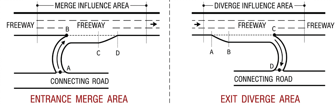
Figure 2. Schematic Diagram of Highway Ramp Merging and Diverging Areas

Figure 3. AI-Based Traffic Flow Detection Using Aerial Imagery