Highway slope close-range photogrammetry automated cloud service system
- Date:2019-03-07
- Update:2019-03-07
- Department:IOT
Project Overview:
Close-range photogrammetry is based on technologies that reconstruct images into three-dimensional renderings, which can turn the results of high-precision measurements and into three-dimensional reconstruction of surfaces. The purpose of this project is to establish a highway side slope close-range photogrammetric standard construction procedure and integrate automatic solutions and data management modules, to provide fully automatic three-dimensional reconstruction of slope surfaces and multi-period three-dimensional data differential analysis, to record the overall side slope changes along roads, as the basis for judging collapse potential and for decision-making by the competent authorities in charge of highways .
Research outcomes:
(1)Established close-range photogrammetry technology used in the standard construction procedure of road side slope monitoring, including the applicability of different side slopes, the planning and deployment procedures for image monitoring equipment, materials, size of automated identification signs and other deployment methods, control point and monitoring point deployment principles, to standardize and simplify operating procedures, and provide a mandatory basis for units to follow, and obtain reliable information accordingly.
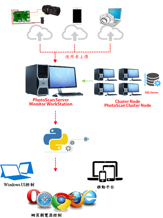
(2)Used Internet of Things (IoT) architecture combined with monitoring module (digital camera + small pad computer) and solver server to provide on-site automated continuous photography monitoring and data return server solutions; system operation architecture developed with programming language Python, construct fully automated image data acquisition, 3D terrain data reconstruction, multi-period terrain data difference comparison and a database query system.
Promotion of Outcomes and Benefits :
(1)The outcomes are promoted to competent authorities in charge of highways such as: Freeway Bureau, Directorate General of Highways, and Taiwan Railways Administration, etc., on the use of side slope inspection and monitoring management, to reduce on-site manual exploration and enhance management efficiency, and we have organized education and training.
(2)This project established close-range photogrammetry technology used in to the standard construction procedures for road side slope monitoring, automated 3D reconstruction and provided multiple time sequence comparative analyses, used to record road slope changes and analyze the collapse potential with lower construction cost, to achieve the effect of three-dimensional reconstruction of the slope automatic surface as well as data comparison and management, and reduced the on-site manual survey and improved management efficiency.
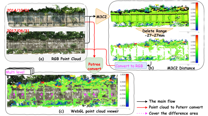
(3)The core of the automated 3D reconstruction calculation developed by this project is that it also only requires a handheld or unmanned aerial vehicle (UAV) mounted with a camera to photograph the targeted side slopes during side slope inspections operation, then upload the images to this system to perform automated three-dimensional rendering, and record the surface data of side slopes with quantitative methods to complement the insufficiency of visual inspections.
Summary of Key Research Outcomes :