Assessment of the impact of vessel navigation on air pollution along the coast and in harbor areas
- Date:2019-03-07
- Update:2019-03-07
- Department:IOT
Project Overview:
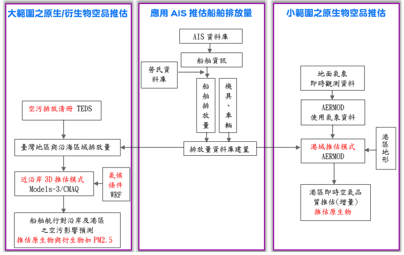
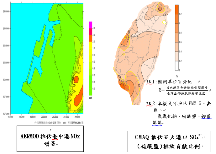
In recent years, air pollution has received much attention from all sectors, and air pollution from vessels cannot be ignored. The vessel emissions cannot be directly equated to direct impact on the environment since these emitted pollutants will be affected by atmospheric conditions (airflow, wind direction, wind speed, temperature, humidity, radiation, sedimentation, etc.) and will engage in chemical reactions (gas phase, liquid phase, solid phase, photochemical reaction, etc.) with other pollutants, to form pollutant concentrations in the surrounding living environment that cause different degrees of harm. This research has two major focuses: (1) Use the AERMOD air diffusion model of the US Environmental Protection Agency, combined with the automatic identification system AIS of the Taiwan Central Weather Bureau and this Institute and other data to construct a real-time air quality estimation system for the Port of Kaohsiung Area and Port of Taichung Area to understand the incremental spatial distribution of primary air pollutants (such as NOx and SOx). (2) The case study of using the AIS data and the Lloyd's database to estimate vessel emissions in a 20 nautical mile radius around these harbor areas, and adopt the CMAQ air quality grid mode, combined with the Air Pollution Emission Register (TEDS 9.0) of the Environmental Protection Administration to construct the Taiwan Area Emissions and Weather Research Forecasting (WRF) data of the Central Weather Bureau, to estimate the impact of ship emissions from Taiwan's major harbor areas and surrounding sea areas on Taiwan's air quality.
Research outcomes:
(1)Constructed a real time air quality estimation system for the Port of Kaohsiung Area and Port of Taichung Area to understand the incremental spatial distribution of its one time primary air pollutants (such as NOx and SOx), thus providing real time emissions of high pollution sources, in order to facilitate timely elimination and reduction of air pollution.
(2)The basic operation mode was completed for the CMAQ model in 2017. The real time vessel emission estimation module was established in 2018. The real time meteorological module will be established in 2019. The impact estimation system of vessel emissions on air quality will be improved gradually, to be used as the basis of conducting air quality forecasting in the future.
(3)The research outcomes can serve as a reference for the Ministry of Transportation and Communications, Maritime and Port Bureau, Taiwan International Ports Corporation or Environmental Protection Administration to develop air pollution countermeasures in the port area and along the coast, to enhance the international competitiveness of the ports and ensure the sustainable development of environment.
Promotion of Outcomes and Benefits :
(1)A number of outcomes and education and training sessions have been organized for the Maritime and Port Bureau, Taiwan International Ports Corporation, Environmental Protection Administration and consultant companies, which were helpful for communication and promotion, and will continue to organize educational trainings in the future.
(2)This Institute has attended the business conference of the Ministry of Transportation and Communications and Management Meeting of the Taiwan International Ports Corporation to present the research outcomes and benefits of the project, in order to facilitate the subsequent promotion and application.
Summary of Key Research Outcomes :