Harbor Environment Information System and Early Warning Application
- Date:2019-03-07
- Update:2019-03-07
- Department:IOT
Project Overview:
The Harbor Environment Information Network of this Institute includes seven query functions of marine observation information, marine simulation information, blue highway information, port image information, port earthquake information, tsunami simulation information and atmospheric corrosion information, to provide integral and real time marine information as a reference for government agencies and the general public. Based on the immediate application of marine information and with stronger requirement of converting into reliable information, the network integrates observation information, information quality control, information real time display and information check and verification, statistical analysis has its necessity of implementation.
Research Achievements:
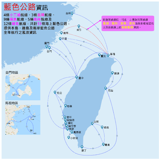
(1)Consolidated and constructed 33 marine blue highway ships movement and marine meteorological information system, to strengthen the ship navigation safety between the island and offshore islands. The blue highway is constructed with integrated Taiwan marine real time observation system, Taiwan coastal marine simulation operation system and ships movement dynamics support system. The system can provide the vessel position, vessel name, speed and direction information, as well as wind speed, wind direction, wave height and wave direction where the vessel is located.
(2)Since 2011, this Institute has cooperated with Central Weather Bureau, Water Resources Agency, Ministry of Economic Affairs, Taiwan Ocean Research Institute to interface with marine information. The "Harbor Environment Information Website" has gradually become the national marine observation data integrated platform to provide inquiry service of marine information.
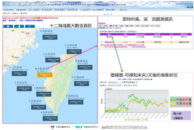
(3)For the first time, Taiwan was organized and divided into 12 maritime areas based on geographical environment and relativity, to conduct long-term statistical analysis on the data of wind, waves, tide levels and currents, and publishes a statistical annual report, annual data reports and a wind special issue, as reference materials for subsequent coastal related engineering design and planning.
(4)Demonstrated the wind speed, wave height and flow velocity, real time and most observation information for the 12 maritime areas of Taiwan. In addition to ordinary enquiries, it can be used to find out the actual changes in 12 maritime areas of Taiwan affected by typhoons when the sea state changesto provide references for the Taiwan International Ports Corporation and the Maritime and Port Bureau.
Promotion of Outcomes and Benefits :
(1)Completed the integration of the Matsu marine meteorological data and the land, sea and air traffic information website "Matsu Go Touring Fun" webpage development in May 2017 and held promotional activities at the airport and port area.
(2)Convened the “National Marine Database Walrus Database Research and Discussion Conference” in September 2017, attended by research units of the Coastal Ocean Monitoring Center of National Cheng Kung University, Hydraulics Laboratory of National Cheng Kung University, National Sun Yat-sen University and Taiwan Ocean Research Institute, who gave positive feedback on the "National Marine Database"
(3)This Institute won the award for Paper Poster Contest of the 39th"Ocean Engineering Seminar and the Ministry of Science and Technology Project Outcomes Achievements Presentation" with the Research Outcomes in November 2017.
(4)Invited the public sector and research units again in April 2018 to discuss the future implementation direction of the “National Marine Database”.
Summary of Key Research Outcomes :