


AI-Based Drone to Safeguard Road Junction Safety
- Date:2020-12-01
- Update:2024-01-31
- Department:Transportation Safety Division
Road accidents frequently occur. More than 50% of car accidents occur at road junctions. In addition to causing the loss of lives and property, road congestion also results. In order to reduce the occurrences of such unfortunate events, the Institute of Transportation, MOTC has incorporated two of the currently most popular technologies in recent years, namely drone aerial photography and AI intelligent image recognition, to develop road junction collision analysis software. It can detect from above the status of collisions between two approximating vehicles and record it in order to understand which road junctions are prone to collision. These road junctions where collisions frequently occur are also the most prone to car accidents. Therefore, this road junction collision analysis software can help the concerned road authority to understand possible hot spots of road junction hazards and carry out improvement in advance.
According to the statistical data of the National Police Agency, Ministry of the Interior, the road traffic accidents from January to September, 2020 totaled 260,000 cases. Among them, 56.5% occurred at road junctions. Every driver has experienced sudden braking at road junctions. The reasons for suddenly braking possibly include the car in front suddenly reduces its speed, a vehicle from the side suddenly cuts in and turns left or right, etc. Regardless of the reason, sudden braking that leaves one in a cold sweat of anxiety is also a type of collision. If failing to brake in time, a car accident results. Through drone aerial photography from a high altitude, the complete moving paths of automobiles, scooters, bicycles and even pedestrians at road junctions come into view. Then, through AI intelligent image recognition technology, the trajectory, time and speed of vehicles and pedestrians can be identified and recorded. Therefore, the concentrated locations of road junction collisions can be analyzed. Subsequently, by means of display using a hotspot diagram, the road junction collision hotspot diagram is plotted and different colors are used to present collision severity.
Collision analysis is performed through drone aerial photography. Since only images of vehicles from the top are captured, rather than vehicle plate number or faces, there will be no infringement of privacy. In addition, since all fly missions are carried out using registered or certified drones and by certified operators. Moreover, an application for a permit to fly should be filed at the Civil Aeronautics Administration, MOTC or at the local government. At the same time, it has insured in public liability insurance in the sum of NT$18 million. During fly missions, take-off and landing site preparation, pre-flight inspection, official flight and post-flight inspection in compliance with the standard operating procedures are required to minimize the risk of accidents.
In the past, road competent authorities learned about road junction safety problems only after occurrences of accidents and improvements were then made to prevent recurrences of accidents. In the future, with the help of collision analysis software, it will be possible to improve road junction traffic safety in advance before accidents occur (e.g., at road junctions where right-turn collision frequently occur, right turn lanes and turning radius adjustments can be made). In the coming year, the Institute of Transportation, MOTC will cooperate with the county and city governments. The collision analysis software will be used to carry out traffic safety improvement work. Additionally, the analysis technology will be extended to other hazardous situations, such as ignoring yellow traffic lights or running red lights at road junctions, thereby enhancing road junction safety.
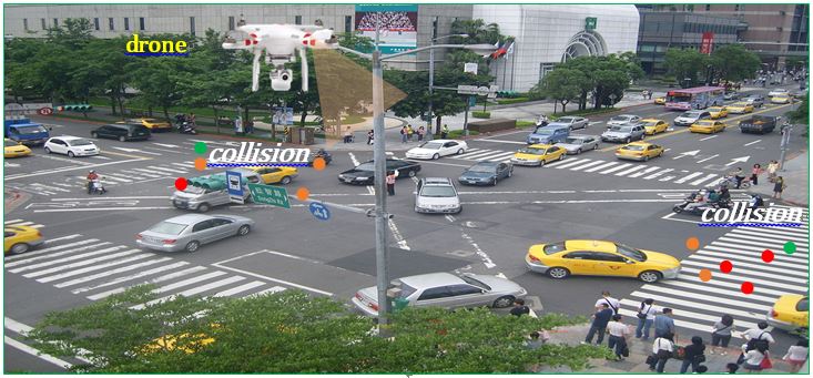
Figure 1 Schematic diagram of drone aerial photography
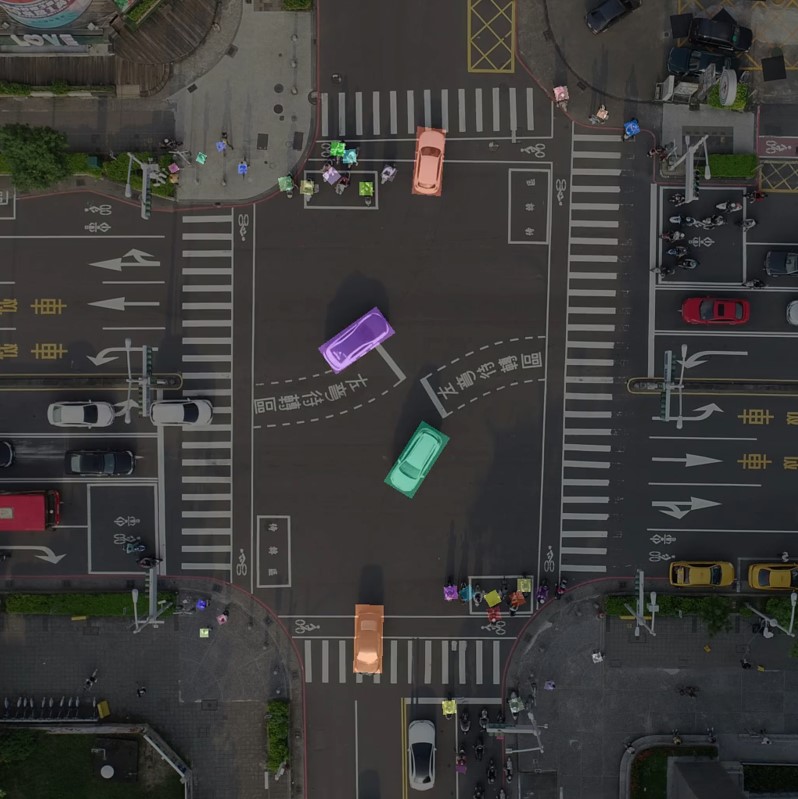
Figure 2 Auto automobile, motorcycle, pedestrian recognition
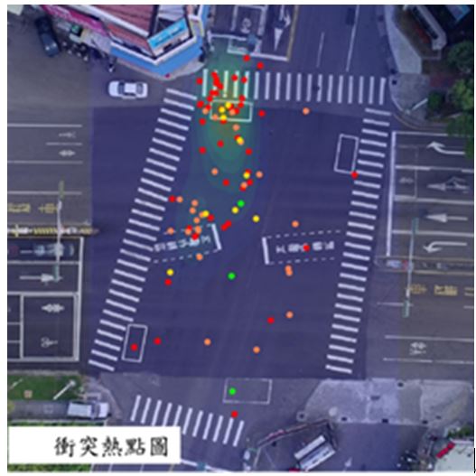
Red: critical collision; orange: high-risk collision;
yellow: medium-risk collision; green: low-risk collision
Figure 3 Road junction collision hotspot diagram